Study Notes
GCSE Geography | Physical Causes of Flooding (River Landscapes 7)
- Level:
- GCSE
- Board:
- AQA, Edexcel, OCR, Eduqas
Last updated 25 Apr 2024
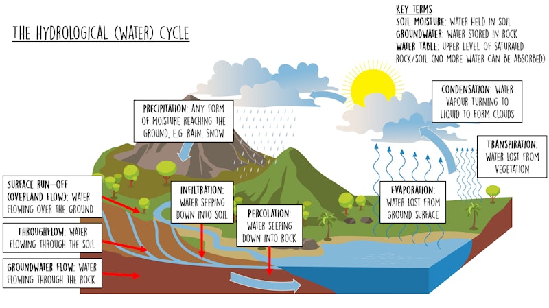
In order to understand physical causes of flooding you need to understand the hydrological (water) cycle, which shows how precipitation returns to a river....
There are several physical factors that increase the risk of flooding...
Weather events
Heavy rainfall is the main cause of flooding. Flooding from heavy rainfall can happen in two ways:
Slow building floods - these are caused by prolonged heavy rainfall caused by bands of depressions passing over the UK, particularly during winter. Continuous heavy rain leads to saturated soil that cannot absorb any more water, leading to increased surface run-off which causes rainwater to enter the river quicker, so river discharge increases rapidly, making a flood event more likely.
Flash floods - these are caused by sudden heavy downpours of rain which overwhelm drainage systems causing, surface run-off. Flash floods rise quickly, however they also subside quickly as the water starts to infiltrate or drain away. Flash floods sometimes occur after a period of drought when the land has been baked hard, preventing infiltration.
Sudden snowmelt can also lead to flooding after the water stored as ice is suddenly released.

Relief
Relief refers to the height and shape of land and has a big impact on flood risk...
Steep slopes increase the likelihood of flooding because it is easier for rainfall to flow down the slope as surface run-off rather than infiltrate the soil. The steeper the valley, the more likely it is to flood.
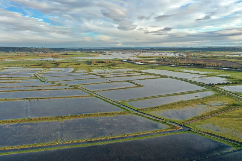
Low-lying areas also have a high flood risk - this is because flood water can spread out easily over a large area, but the gradient is too flat to enable the water to move out of the area quickly. A good example of this is the Somerset Levels flooding of winter 2013/14 where excess water had to be pumped out.
Geology
The type of rock in an area can increase the risk of flooding, and geology is often linked to relief...
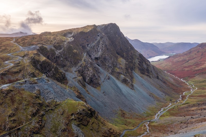
Upland areas are often made from impermeable rock such as slate, which leads to very distinctive landscapes. Impermeable rock doesn't allow water to pass through so infiltration cannot occur. Mountainous landscapes often have bare rock with thin soils and little vegetation to intercept rainfall. In areas like the Lake District, excess rainwater flows down the slopes as waterfalls which then disappear a few days later, once surface run-off has subsided.
Low-lying areas are often covered in impermeable clays. Whilst there is vegetation to intercept rainfall, infiltration doesn't really occur as clay soils are very compacted, so water cannot get through.
Areas with permeable rock, such as limestone and chalk have a much lower risk of flooding as the water can pass through these rocks, decreasing surface-runoff.
Precipitation, relief and geology are all linked and combine to increase the likelihood of flooding, for example, the Lake District in north-west England has one of the highest rainfall totals in the UK, and steep slopes mainly made from impermeable slate so flood events are regular here. A good example here is the devastation caused in the village of Glenridding in December 2015 following Storm Desmond which had caused 341.4mm of rainfall in 24 hours - the highest ever recorded in the UK.
You might also like
Rivers: Lower Course Processes and Landforms
Study Notes

3 great simulation games for geography lessons
2nd February 2016
River Floods
Study Notes

Mudslides in Sierra Leone
15th August 2017
Is Flooding in Essex Linked to Antartica?
16th August 2017
16 million people affected by seasonal floods in southern Asia
19th August 2017

Before and After Flooding in Houston
27th August 2017