Study Notes
GCSE Geography | Landforms in the Lower Course (River Landscapes 6)
- Level:
- GCSE
- Board:
- AQA, Edexcel, OCR, Eduqas
Last updated 22 Sept 2023
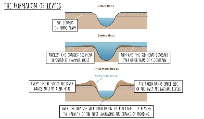
Depositional processes in the lower course of the river lead to the formation of levées and floodplains.
Periods of prolonged heavy rainfall causes discharge in a river to rise meaning that the river level will rise above the banks and flood the surrounding land. Over time repeated annual flooding will lead to alluvium and sediment being deposited, forming levées and flood plains.
How are levées formed?
Levées are naturally raised river banks found the sides of a river channel that is prone to flooding. They are formed after a flood deposits sediment on the flood plain close to the river - as the water is spilling out across the land its velocity is reduced because of friction which leads to deposition. The heaviest sediment is deposited close to the river channel, with smaller particles deposited further away (see the shape of the levées in the diagrams below).
Each time the river floods more sediment is added to the river banks, building them up further. These levées should reduce the likelihood of future flood events, however they don't, because at the same time as the banks being built up by sediment deposits, the river bed is being raised by a thick layer of sediment, reducing the channel capacity.
What are levées like?
- They are significantly higher than the original river bank - anything between 2-8 metres high
- They are made of sediment including gravel, stones and alluvium - alluvium is extremely fertile so add nutrients to soils by the river which makes floodplains a good place to grow crops
- The sediment is much coarser closer to the river channel - this is because the heaviest material is deposited first
- They have a distinctive shape - they are much steeper on the side facing the river channel (see diagram above)
- The tops of levées are relatively flat and are usually naturally covered by grass, so are often used as footpaths
How do flood plains form?
Flood plains are large areas of flat land either side of the river that are prone to flooding of a regular basis. They are not suitable for building on, although are often developed on!
Flood plains are wide because the valley floor has been eroded outwards (laterally) by migrating meanders - as they move downstream they cut a wider and wider valley.
Each time the river floods it covers the land close to it with deposits of silt and alluvium, which are left behind once the flood recedes - this builds up the flood plain and makes it slightly higher each time it floods. Old meander scars are also filled in with silt and alluvium.

You might also like

A River Forms - Time Lapse
18th February 2015
Rivers: Lower Course Processes and Landforms
Study Notes
River Floods
Study Notes
River profiles
Study Notes
3 great simulation games for geography lessons
2nd February 2016